GeoGulf Posters
Scroll down to see posters by Andrew Stearns, Sarah Meyer and Caroline Ramon-Duenas.
The Source // Andrew Stearns
Quantifying Hurricane Harvey Sediment Transport in the Houston - Galveston Region

Supplementary Information
Abstract
Hurricane Harvey made landfall as a Category 4 hurricane in Port Aransas, Texas on August 26, 2017 and produced an extreme precipitation event over Houston, Texas. Harvey stalled out southwest of the Houston area from August 28-30 after weakening to a tropical storm. This resulted in many areas recording greater than 3 feet of precipitation which equaled or exceeded the 1000-year event return period according to the National Hurricane Center. The ensuing 2.6 mi3 of runoff is thought to have caused mobilization of large sediment volumes within fluvial-estuarine systems in the Houston-Galveston region. Thick flood deposits from significant precipitation events decreases the bankfull volume capacity of rivers causing them to be more susceptible to future flooding. We propose a quantitative method to determine the total sediment budget in the Houston-Galveston area during Hurricane Harvey using pre- and post-Harvey high-resolution digital elevation models (DEMs), and sediment dredging reports along major waterways. Elevation difference maps along Buffalo Bayou from before and after the storm show sand bar flood deposits 3-15 feet high within the natural portion of the river from I-610 to Shepard Drive. In addition, 420,000 ft3 of sediment has been removed along Buffalo Bayou from Shepard Drive to downtown Houston according to the Buffalo Bayou Partnership. For the West San Jacinto river entering Lake Houston, 63,423,000 ft3 of sediment was removed by the US Army Corps of Engineers. The preliminary results indicate sediment mobilization from the uplands to the west-northwest of Houston, and substantial deposition of these sediments corresponding to a break in slope in the stream elevation profile. Similar trends of substantial sediment mobilization are projected for the other fluvial-estuarine systems in the Houston-Galveston region, which could provide implications for future flood control.
Acknowledgements
We would like to Dr. Julia Wellner and Jerry Kendall for their contributions with sample collection, processing, and helpful edits. Additionally, USGS and TENRIS for providing the publicly available GIS data files.
References
AECOM, 2012, Stream Technical Report Final 1-27-12, Charting Buffalo: A Collaborative Study of Buffalo and Lower White Oak Bayous. P. 1-390
Anderson, J. B., 2007, the Formation and Future of the Upper Texas Gulf Coast: A Geologist Answers Questions About Sand Storms, and Living by the Sea, p. 1-163.
Blake, E. S. and D. A. Zelinsky, 2018, Hurricane Harvey: National Hurrican Center Tropical Cycle Report, p. 1 - 77. Carlowicz, M. and J. Allen, 2017, Texas Waters Run Brown After Harvey: NASA Earth Obervatory, Land Atmosphere Near Real-Time Capability for EOS.
Du, J., Park, K, Dellapena, T. M., and J. M. Clay, 2018, Dramatic Hydodynamic and Sedimentary Responses in Galveston Bay and Adjacent Inner Shelf to Hurricane Harvey, Science of the Total Environment, v. 653, p. 554 - 564, doi: /10.1016/j.scitotenv.2018.10.403.
Fovenyessy, S. and S. F. Patternson, 2019, Wind or Water? Hurricane Harvey’s Most Destructive Force: Earth Magazine April 2019, p. 28 - 35. Greater Houston Flood Mitigation Consortium, 2018, How do Addicks and Barker Reservoirs Work?: Briefing Document #2, p. 1-4.
Linder, J. and S. Fitzgerald, 2018, Immediate Report - Final Hurricane Harvey - Storm and Flood Information: Harris County Flood Control District, p. 1-32.
Sebastian, A., Lendering, K., Kothuis, B., Brand, N., Jonkman, S.N., van Gelder, P., Godfroij, M., Kolen, B., Comes, T., and Lhermitte, S., 2017, A Fact-Finding Effort in the Direct Aftermath of Hurricane Harvey in the Greater Houston Region: Delft, p. 1-102.
Texas Natural Resources Information System (TENRIS), 2004-2019, Hydrologic, Roadways, Boundaries, and Elevation GIS Datasets.
United States Geologic Survey (USGS), 2019, Stream Gauge Height at Station 08074000 on Buffalo Bayou: National Water Information System.
van Oldenborough, G. J., van der Weil, K., Sebastian, A., Singh, R., Arrighi, J., Otto, F., Haustein, K., Li., S., Vecchi, G., and H. Cullen, 2018, Attribution of Extreme Rainfall from Hurricane Harvey: Environmental Research Letters, v. 13, p. 1-11, doi: 10.1088/1748-9326/aa9ef2.
Interpretation // Sarah Meyer
Interpretation of Sands Deposited in Buffalo Bayou During Hurricane Harvey

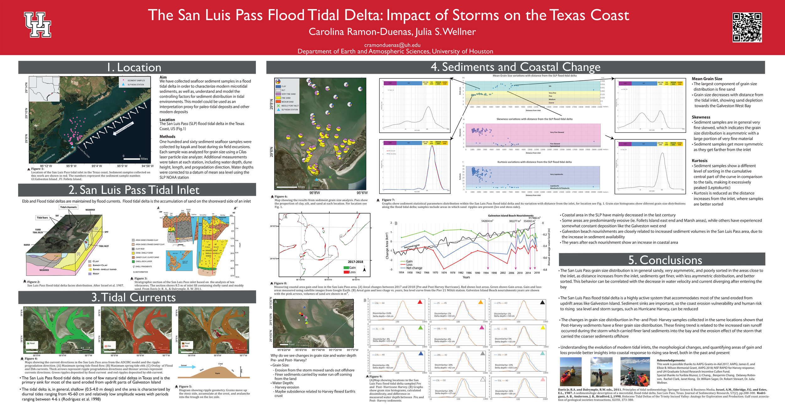
The Sink // Carolina Ramon-Duenas
The San Luis Pass Flood Tidal Delta: Impact of the Storms on the Texas Coast
Supporting files:
