Buffalo Bayou Hurricane Hike
A walking tour of Hurricane impacts on Buffalo Bayou Park
〰️ bayuk 〰️
〰️
〰️ bayuk 〰️ 〰️
OUR LAND ACKNOWLEDGEMENT
Buffalo Bayou sits on the unceded traditional land of the Atakapa-Ishak, Caddo, Coahuiltecan, Karankawa, and Tonkawa peoples. “Bayou” is believed to come from the Choctaw word “bayuk” meaning “small stream”. The name "Texas" comes from the Caddo word táysha which means "friend". We honor, with gratitude, the Alabama-Coushatta, Aranama, Aztec, Choctaw, Athabaskan, Comanche, Jumano, Kickapoo, Kiowa, Maya, and all Indigenous peoples who have inhabited this place for generations. They continue to remain in relationship with the land and resources through ceremony, culture, and stewardship.
〰️ bayuk 〰️
〰️
〰️ bayuk 〰️ 〰️

Figure 0.1. Buffalo Bayou watershed in Houston area and on the scale of Texas. A relatively small watershed, but critical for Houston.
Introduction to the Field Trip
Buffalo Bayou is the reason Houston exists. The riches of the Texas prairie were able to flow down Buffalo Bayou to gain access to the sea and global trade (Fig. 0.1). Unfortunately, on occasions of extreme water flow down Buffalo Bayou, areas that encroach onto the bayou are adversely impacted with flooding water. This trip started as a collaborative effort to examine the artistic value of the geologic archive resulting from the Hurricane Harvey flood of August 2017 in Buffalo Bayou Park (Fig. 0.2). We will see the sedimentary record archive of Harvey’s flow and its parallels in the hydrologic and human impact archives. The hike has expanded to include additional flood events, both in the past and those to come.
This hurricane hike takes you on a walk through space and time to consider the records of hurricanes in Buffalo Bayou Park.
Let's start with Time in Houston
〰️
Let's start with Time in Houston 〰️
Recent Time
〰️
Deep Time
〰️
Very Deep Time
〰️
Recent Time 〰️ Deep Time 〰️ Very Deep Time 〰️
Hike Guides
Developed with K-12 teachers as tool to be used along side this website. It includes suggestions for teaching opportunities and exercises along the hike along with links back to this information.
An 8-page print out of figures and key to accompany the hike.
Hurricane Hike Safety
Each of the stops on the Hurricane Hike include a Safety Summary that identifies hazards and provides emergency contact information and photographs of each stop for easy reference.
Hurricane Hike Stops
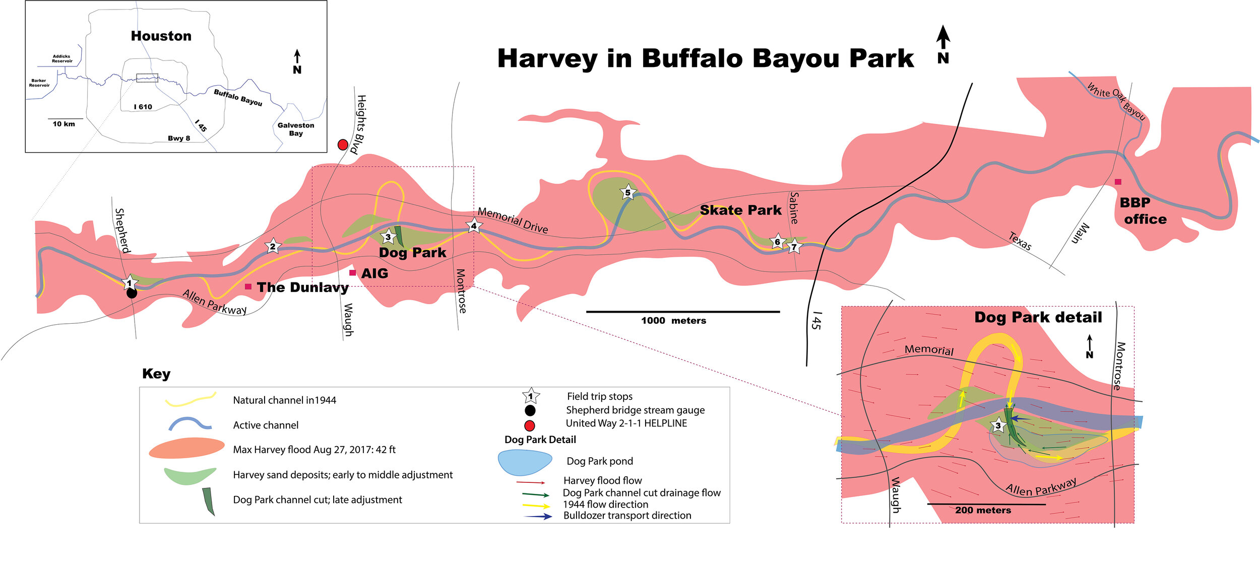
Figure 0.2. Map of the Hurricane Harvey floodwaters in Buffalo Bayou Park with field trip stops shown as numbered stars. The dark blue line is the current active channel, the yellow line is the 1944 channel and the red polygon is the maximum extent of flooding at end of the flood phase (HCFCD, 2017). The green areas mark the extent of 1-4-m (~3-12 ft) thick sandbar deposits. Note the correlation between sandbar deposits and places where the bayou was artificially straightened in the 1970s. Over 272 million kg (600 million lbs) of sediment, enough to fill NRG stadium 3.4 m (11 ft) deep, were removed during the recovery efforts (BBP, 2018). The detail of the Johnny Steele Dog Park area at the lower right shows the sandbar that is later cut by a channel (dark green) draining a pond that formed in the dog park. The red arrows show the net flow direction of the bayou during flood while the green arrows represent the net flow as the bayou adjusted when the water level dropped below ~9 m (~10 ft), draining the dog park.
Figures 0.2 and 0.3 show our 4 km (2.5 mi) route with 7 stops along Buffalo Bayou. Stop 1, 2, and 3 focus on the flow archives of Hurricane Harvey. Stop 4 and 5 focus on the entire Buffalo Bayou system from source to sink. Stop 6 examines the management of the bayou and issues of sustainability and resilience. Stop 7 at the Sabine St. bridge looks towards the future and coexistence of humans within our increasingly more dynamic environment.


Stop 0 // Introduction
Buffalo Bayou is a relatively small drainage on the Texas coast, only ~100 km (~60 mi) long (Fig. 0.1). In August 2017 Hurricane Harvey made landfall on the gulf coast of Texas. In a four-day period, many areas received more than 1000 mm (40 in) of rain as the system slowly meandered over eastern Texas and adjacent waters, causing severe flooding. Dumping more than 6.2 cubic kilometers of rain ( equivalent to 5 days discharge from the Mississippi River) and with a peak rainfall of 1539 mm (60.58 in) in Nederland, TX, Harvey was the wettest tropical cyclone on record in the United States (Roth, 2018). Near-record water levels occurred at every bridge crossing along Buffalo Bayou. The Harris County Flood Control District recorded that 1 out of every 10 buildings in Harris County flooded during Hurricane Harvey (Lindner and Fitzgerald, 2017). Floodwater carried 27 million cubic meters of sediment load (equivalent to 7 times the volume of the Astro Dome) as it swept downstream, flowing down the bayou system to the Gulf of Mexico. In Buffalo Bayou Park alone the storm deposited over 272 million kg (600 million lbs) of sediment, enough to fill NRG stadium 3.4 m (11 ft) deep (BBP, 2018).
Safety Summary
〰️
Safety Summary 〰️
Parking
The closest parking to the start of the hike is street parking at Autry Park parking lot off Marston street or Tiel Way. There is limited parking at Flora restaurant. There also is parking at the Sabine St. bridge at the end of the hike.
Note that crosswalks at the intersection of Kirby Dr. and Shepherd Dr. are poorly marked and complicated, with cars turning from many unexpected directions. Be alert getting to the starting point.
Trail Access
This hike is mostly on paved trails with a few excursions onto the muddy banks of the bayou. Slips, trips and falls are your biggest hazard. The bayou can flow fast and its banks can drop off steeply. There are biting insets and poison ivy off the paved trails. You will be sharing the trails with bikes and runners so be alert to their approach.
What to Bring
As always, sun screen, water, and bug spray are good precautions. Bathrooms and water are located at Flora and at the Lee and Joe Jamail Skate Park. The primary objective is that nobody gets hurt.

Figure 0.3. Buffalo Bayou Park near the end of the middle adjustment phase when the lower energy sandbar bedforms were being deposited. The field trip stops and route (blue) are shown.
Sponsors
The Buffalo Bayou Hurricane Hike is supported by a generous grant by the AAPG Foundation and endorsed by AAPG Division of Environmental Geoscientists.


The Buffalo Bayou Hurricane Hike was originally developed as a Field Guide for a field trip in conjuncture with the GeoGulf Convention October 2019. In 2024 the hike was updated with support from AAPG to include a teachers guide written for K-12 science teachers and students.