Hurricane Harvey // Sand Peel Sculpture 2
Plate 12A. Sand Peel Sculpture 2
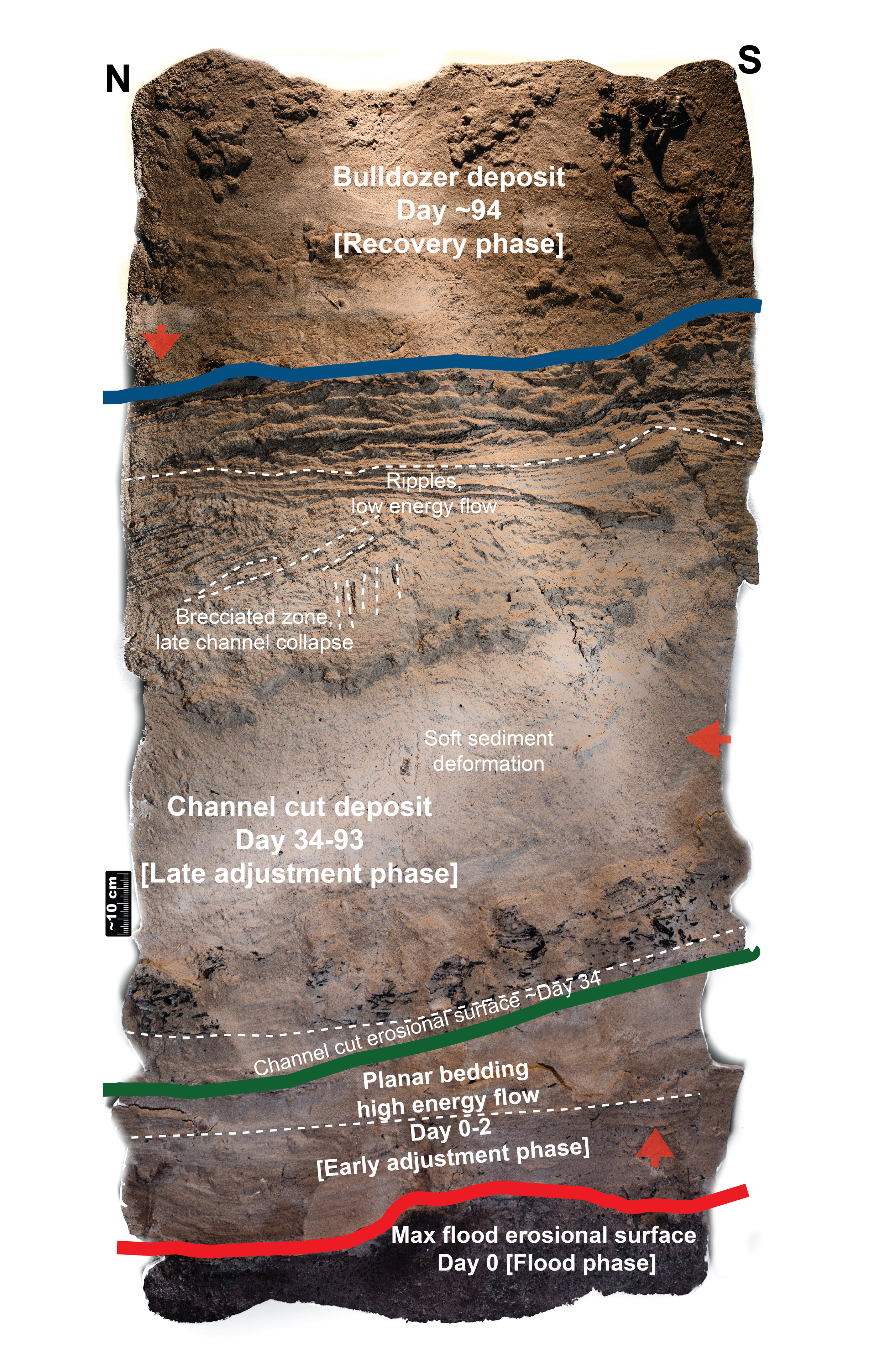
Plate 12B. Sand Peel Sculpture 2 Interpretation
Context, Description, and Interpretation:
Peel 2 records the flood, adjustment and recovery phases of Hurricane Harvey. The peel shows the initial erosion during the maximum flooding phase, followed by rapid deposition of sands as the energy levels quickly dropped, then a late adjustment as flow changed direction 90 degrees as water levels returned to the original channel. The bulldozer deposit in the top third of the peel records the recovery phase. The hydrologic archive shows the water level’s rapid rise and fall and the return to channel > 30 days post maximum flooding. The human impact as demonstrated by 211 calls changed from immediate needs like food and shelter to financial needs when the flow direction changed, and to mental trauma and medical needs in the recovery phase.
Summary: This peel records all phases of Hurricane Harvey along with three directions of sediment transport. Above the maximum flood erosional surface (red line), upper flow regime bedforms were deposited in a river bar, followed by the channel cut erosional surface (green line) and the overlying channel cut deposit. Above the blue line near the top of the peel there are no sedimentary structures because the sediment was transported by bulldozer.
At the base of Peel 2, there is a mud layer with a large basal scour in it, representing pre-Harvey sediments topped by the Hurricane Harvey maximum flood erosional surface (red line). Above this erosional surface is planar bedding of a river bar deposit, indicating upper flow regime and high flow velocity. Above the planar bedding is an erosional surface marking the cross-cutting channel (green line). Overlying this surface there is a thick package that has undergone soft sediment deformation caused by a rapid influx of sediment. Higher in the section is a well-defined brecciated zone, where laminations were broken up and transported as a result of late channel collapse. Above the brecciated zone, gently climbing ripples indicate a fast sedimentation rate and a high amount of suspended sediment. At the top of Peel 6 the absence of sedimentary structures above the blue line indicates the deposit was reworked by bulldozer during Hurricane Harvey recovery. The red arrows indicate the easterly flow direction above the red line, northerly flow above the green line, and westerly transport by bulldozer above the blue line.
Event Timing
Flood phase
August 28, 2017: The red line marks the erosional surface above the low energy pre-Harvey deposit. This erosion occurred during the flood phase as Buffalo Bayou rose to its peak at about 1:00am on August 28, with a measured gauge height of 15 m (41.9 ft). Flow was to the east.
Early adjustment phase
August 28-30, 2017: The water level dropped rapidly through August 30, with flow conditions were in the upper flow regime. On Peel 2, the sediment deposited during this time is between the red line and the green line. Flow was to the east.
Late adjustment phase
October 1-November 29, 2017: The channel cut occurred during this time. On Peel 2, these deposits are between the green line and the blue line. Flow changed direction from east to north.
Recovery phase
November 30, 2017: As part of the Hurricane Harvey recovery effort the city of Houston used bulldozers and trucks to remove 600,000,000 lbs of sediment from Buffalo Bayou Park. Sediment reworked by bulldozer is above the blue line. Transport direction was to the west.